Fernhill Wetland Master Planning and Design

Fernhill Wetlands is part of a 748 acre parcel near Forest Grove, OR, owned by Clean Water Services and managed in partnership with Forest Grove.  The site, located within the Tualatin River Watershed, consists of agricultural fields, wastewater treatment and other public utility facilities, and several pristine wetlands which are open to the public and draw birders from far and wide who come to observe the many rare migratory bird species that stop at the wetlands during their journey.
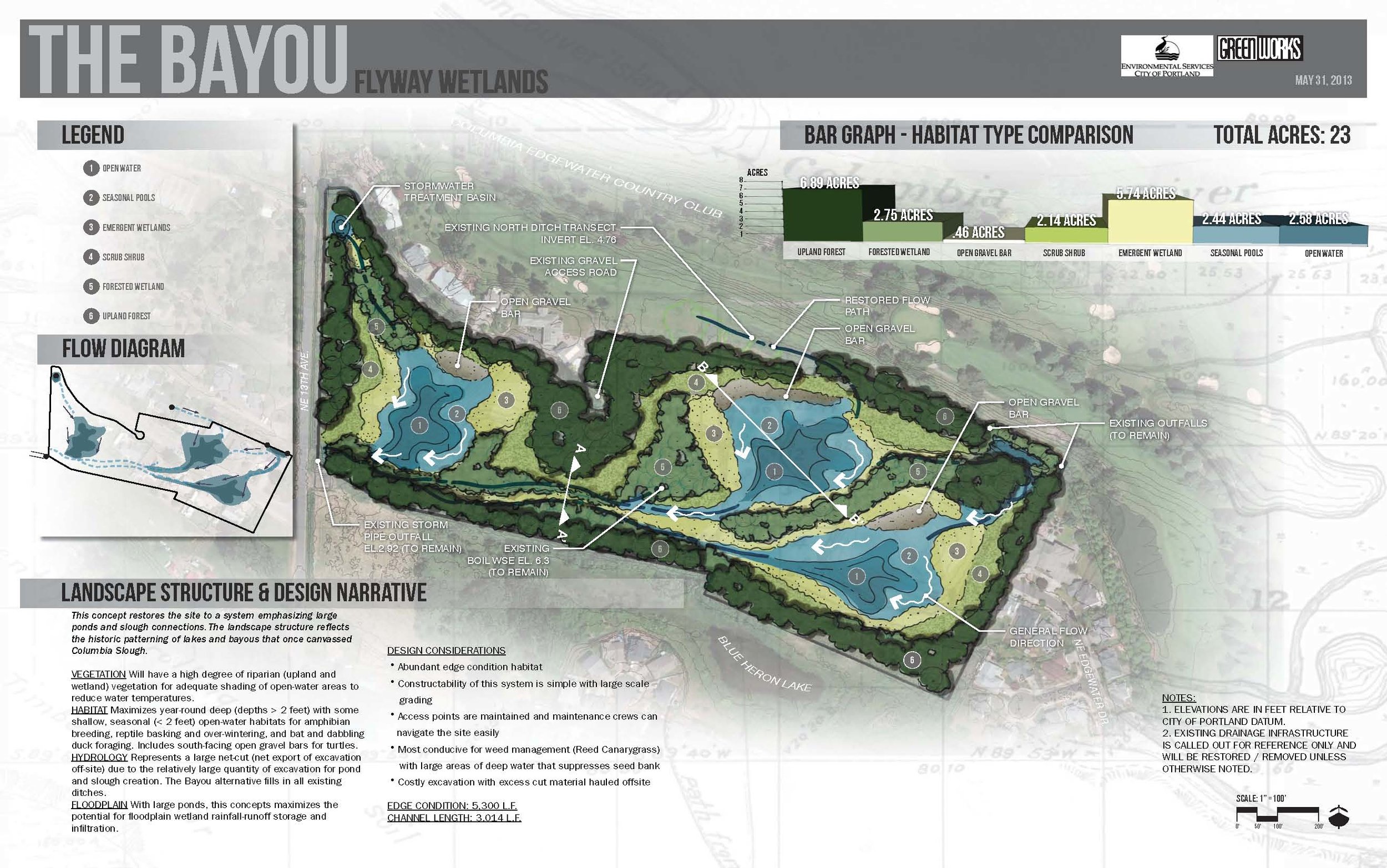
With future plans to integrate the wetlands into the wastewater treatment process as part of a natural and sustainable cleansing and cooling approach that preserves the site’s ecological and recreational significance, Clean Water Services commissioned GreenWorks as consultants who bring extensive experience in constructed wetland and green infrastructure design.  In collaboration with CWS, GreenWorks developed a master plan vision for the site which included an overall site layout consisting of treatment wetlands, roads, trails, overlooks and other public spaces; a graphic representation of the water circulation path from wastewater treatment facility all the way to the Tualatin River; accompanied by a collection of artistic photorealistic renderings from various vantage points, which will collectively be used to clearly convey design intent throughout future project phases.

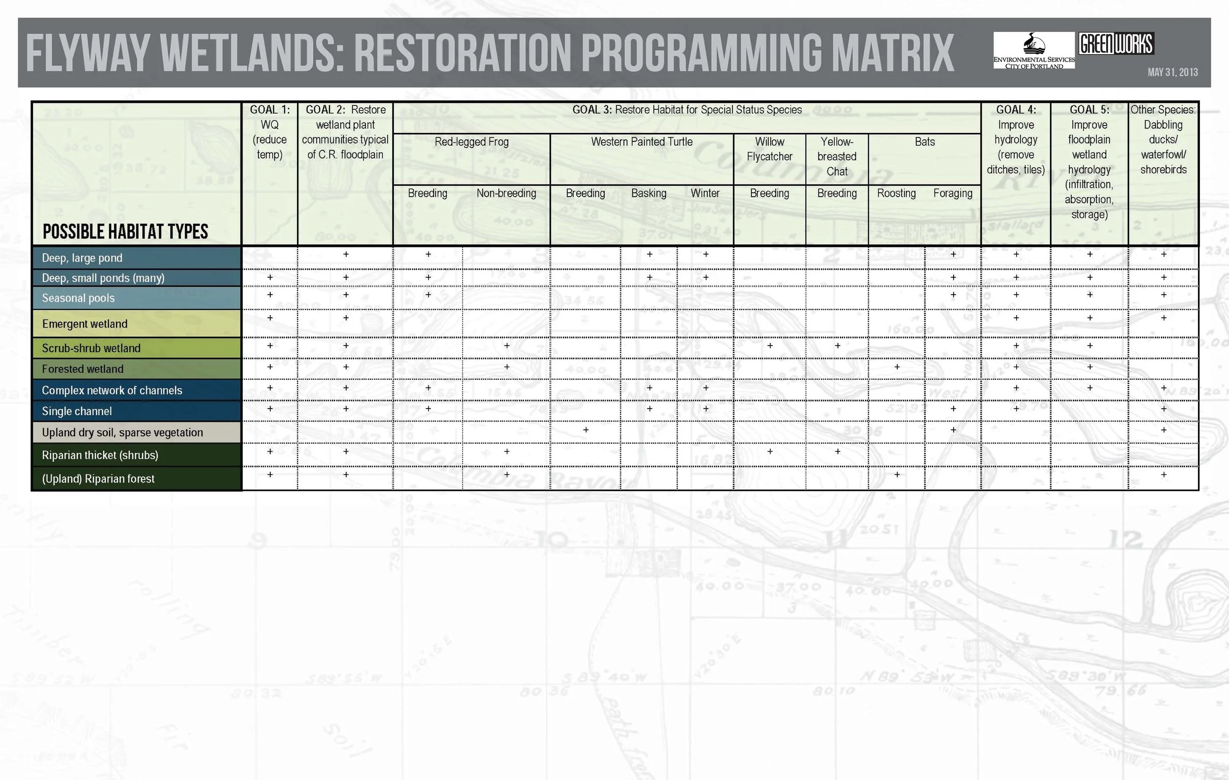
The Unified Sewerage Agency contracted with GreenWorks as part of a team of engineers, biologists, and hydrologists, to develop wetland development concepts for a large-scale wetland mitigation bank, along Gales Creek in Forest Grove. The concept plan recommendations included the establishment of ash forest wetland, emergent marsh and scrub-shrub wetland, wet meadows, and oak woodland upland buffers.

fernhill (1).jpg
fernhill (2).jpg
fernhill (3).jpg
Fernhill_Wetland.jpg

Gresham Fairview Creek Regional Stormwater Facility

As a subconsultant for this regional water quantity and quality control project, we were responsible for design development of the four acre water quality facility, which includes a sedimentation pond with a wetland treatment facility. The wetland treatment facilities incorporates an emergent marsh, scrub-shrub community, and a riparian forest. Our tasks included preparation of graphic illustrations for a public meeting, at which we were present to answer questions.

Fairview Creek Regional Stormwater Facility.JPG

Rock Creek Greenway

boardwalk_rock_creek_cloudy.JPG

Hillsboro Parks and Recreation contracted with GreenWorks and an interdisciplinary team to evaluate opportunities and constraints and propose recommendations for a 2500 foot section of Rock Creek.

Project goals included reconnecting the creek to its floodplain, enhancing floodplain fish and wildlife habitat, and providing passive recreation opportunities for the greenway.

GreenWorks designed a concept plan including new stormwater treatment facilities between adjacent developments and the riparian corridor, a backwater habitat, overall vegetation management strategies, trails, overlooks, and a pedestrian bridge crossing.

black and white image from airplane, ponds and stream amidst track homes
crane delivering trail bridge with workers and a forest around
a meadow around rock creek greenway with new nurse logs on a sunny day
rockcrkenhpln.jpg

BES Johnson Creek Oxbow Restoration

IMG_9919.jpg

In November of 2014 GreenWorks began a site assessment and preliminary design for the Johnson Creek Oxbow Enhancement Project. The central feature of the site is the namesake “Oxbow” meander, which is bounded on the south by a bypass channel that truncates the oxbow creating an island. The by-pass channel was constructed by the Works Progress Administration (WPA) in the 1930’s and included armoring the creek bed and banks, and creating a fish ladder in the oxbow to maintain fish passage. The goal of the WPA work was to convey flood flows efficiently downstream. It resulted in a confined channel, which is hydrologically disconnected from adjacent floodplains and wetlands, and exacerbates flooding. GreenWorks was charged with providing design strategies for improving floodplain hydrology, riparian and in-stream habitat, and local flood impacts.


To support these goals, GreenWorks held a one day charrette, which included members from BES, ESA-Vigil Argimis, and KPFF to discuss and recommend a variety of design strategies for improving the inherent conditions found within the Johnson Creek Oxbow. Recommendations were collected and vetted amongst the consultants and further discussed with BES to determine a set of design alternatives for specific sites within the project area. Project sites were mapped, along with support graphics and images, and cost-estimates, to BES in a comprehensive Pre-Design report, thus allowing BES to prioritize future improvement projects for the Johnson Creek Oxbow area.

BES_Oxbow_Perspective.jpg

BES Flyway Wetlands Enhancement

GreenWorks provided landscape architecture services for Portland’s Bureau of Environmental Services Flyway Wetland property located between the Columbia Slough and the Columbia River near the Portland airport. GreenWorks led a team to provide several wetland restoration concepts and a wetland delineation report. GreenWorks headed several workshops with the consultant and team to develop the preferred concepts based on goals for the project including: water quality improvement; vegetation and habitat restoration; wetland hydrology improvement; and floodplain wetland hydrology improvements. Wetland and Stream Delineation Reports and Wetland Restoration Concepts were created for internal analysis related to bureau’s goals for restoring the site and their overarching restoration goals for bureau’s environmental group.

Flyway_Wetlands_Sections_Mosaic.jpg
Flyway_Wetlands_Sections_Bayou.jpg
Flyway_Wetlands_Plan_Concepts_Mosaic.jpg
Flyway_Wetlands_Plan_Concepts_Bayou.jpg
Flyway_Wetlands_Design_Concept_Table.jpg
flyway (5).jpg
flyway (1).jpg