Wade Creek Park

2019_01_07_Wade_Creek_Preferred.jpg

Wade Creek Park Phase III

Greenworks and our sub-consultant Otak worked with the City of Estacada on a preliminary design for Wade Creek Park Phase III, a 3-acre park in Estacada, Oregon. The City has a vision of turning a pond located behind the library into a flowing stream as well as improving its outfall for maintenance and safety. The team conducted a geomorphic and hydrology study, and an assessment of the site by providing surveys for topography and tree health. Two alternatives were presented to the public. In order to cast a wider net of responses, GreenWorks created an on-line survey. The final design comprising of a riffle, pool, and channel complex with riparian plantings, an amphitheater, and walking trails was presented to City Council in early March of 2019 and was approved.

Rendering credit: Otak + Greenworks

Rendering credit: Otak + Greenworks

Conceptual Design for the Wade Creek Park Community Building

We worked as a sub-consultant to Otak to provide design services for the Wade Creek Park Community Building, located to the northwest of the Estacada Public Library in Estacada, Oregon. The building will consist primarily of a multi-purpose room of +/- 1,000 square feet and accommodating approximately 75 to 100 people. The space will adapt to allow many different gatherings using include mobile partitions to subdivide the room. The building will also include a covered stage as part of a planned outdoor amphitheater. The plan includes additional spaces such as a small kitchen, storage room for furniture, utility closets and bathrooms. The conceptual design integrated with and was influenced by the Wade Creek Park Phase Ill master plan. GreenWorks was essential to the project’s coordination, test-fitting the proposed building layouts. The final product of our work was a conceptual design set that expresses the new building’s layout, elevations, roof plan, and assumed materials for the building. A cost estimate was provided as well. The conceptual design was used by the City of Estacada to pursue funding for the project.

Salem Riverfront Park Master Plan

Salem_1_50_MP_board.jpg

Salem Riverfront Park is one of Salem’s premier, treasured, and well used parks. GreenWorks partnered with the City of Salem to update the master plan for Salem Riverfront Park, incorporating an additional four acres of land on the south end of the park.  

The large open lawns, open air amphitheater and views of the Willamette River make the park a favored place for large and small events held throughout the year and it’s a popular place for walking, jogging and getting a breath of fresh air.

Through a robust public outreach process, GreenWorks and City staff worked with focus groups and the public to develop and prioritize concepts for park improvements and additions. A key feature in the new addition to the park is a new, larger amphitheater designed to complement a proposed covered stage and a river viewing terrace with dramatic views of the Peter Courtney Minto-Island Bridge.

Relocating the covered stage and amphitheater to the south end of the park means Salem can host larger events in the park and take advantage of the soon to be upgraded areas: nature play area, terraced overlook seating, playground, splash pad, pavilion, and seasonal ice rink.  

Our updated master plan includes a floating river walk, expanded dock facilities for kayak and canoe rentals, and space for fishing. We also improved connections to other Salem parks, including a future trail along adjacent Pringle Creek and existing links to Wallace Marine Park.

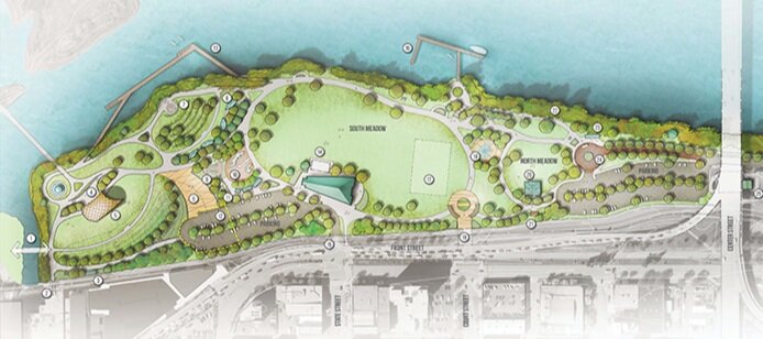
Independence Landing Waterfront Park

Conceived of a an extension of Riverview Park, Independence landing offers users a number of passive recreation opportunities.

Greenworks is honored to be working with the City of Independence to implement the vision set forth in the Open Space Master Plan completed in 2015. The current work on Independence Landing improves a key piece of public waterfront located immediately south of Riverview Park, the flagship of the Independence park system. Designed in tandem with the with the large waterfront re-development on the old Valley Concrete Site, Independence Landing  is one piece in a larger orchestrated effort to revitalize downtown Independence and support commercial growth.

Man-Walks_Park_Willamette_Riverfront_Path.JPG
Independence_Landing_South-View_Oregon_Waterfront.JPG

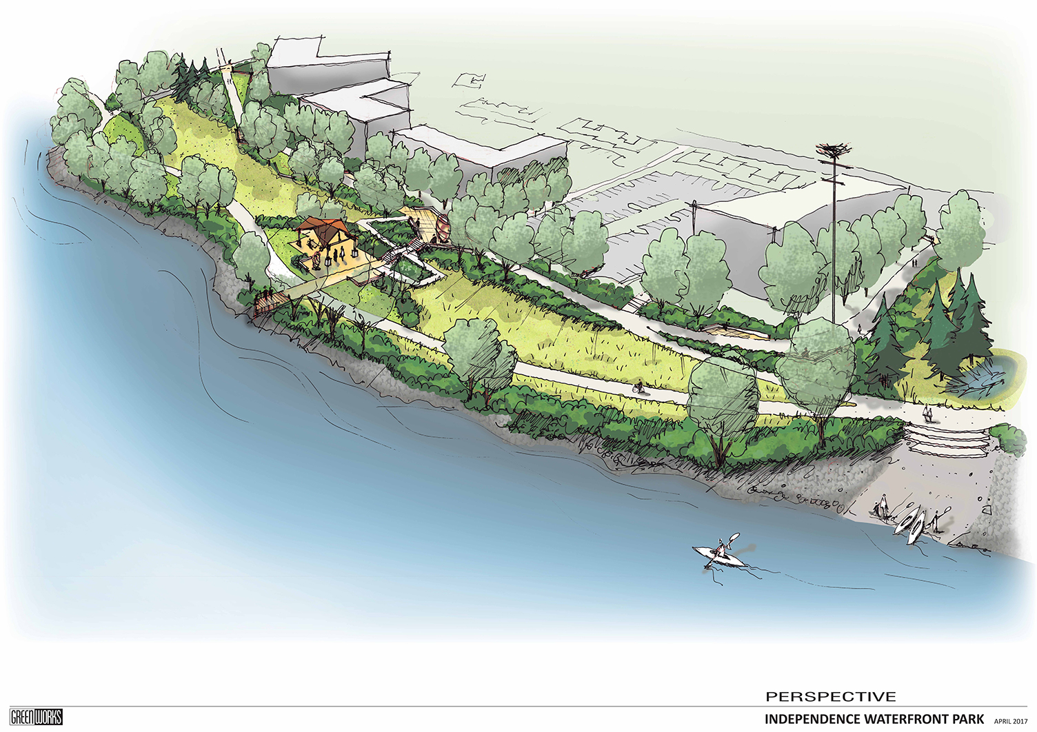
Included in the plan are a waterfront multi-use trail with a river overlook, a shaded patio and lawn space able to accommodate flexible programming, a sizeable restoration planting area braided by soft surface trails and a grove of shade trees in which the user can find informal, private seating areas. This implementation of the Open Space Master Plan sets the stage for the continued expansion of improved public waterfront southward along the Willamette River and strengthens the downtown, pedestrian connections to the waterfront.

The success of this project has been a measure of how well the project team has worked together. Shawn Irvine and David Clyne with the City of Independence and Steve Ward with Westech Engineering have been instrumental in guiding the design process, representing the diverse community of Independence and streamlining the construction of this exciting new park space.

Conceptual Visualization

Independence landing riverfront park plan graphic birdseye
Independence Waterfront Park Perspective Plan Drawing

George Rogers Park

GreenWorks prepared the Master Plan and design services for George Rogers Park located along the Willamette River in Lake Oswego. The project created visual and physical connections to the Willamette River and between elements within the park. Gateway enhancements, interpretive elements, and improved waterfront access were key design components. Creating a cohesive plan was paramount and included unifying the Barbecue Terrace with the Memorial Garden Terrace. The design also provided a soft canoe launch and waterfront access improvements. Boardwalks connected terraces and provided overlooks to the public beach area. The project removed existing pavings within the floodplain and provided mitigation plantings for all encroachments in the floodplain and greenway.

GeorgeRogers_reduced.jpg
GeorgeRogersPark_13_reduced.jpg
03_George_Rogers_Park_reduced.jpg
DSC_0152.JPG
MM_George Rogers Park.JPG
L1.2bsm.jpg
GeorgeRogerswalkreduced.jpg

Spring Park

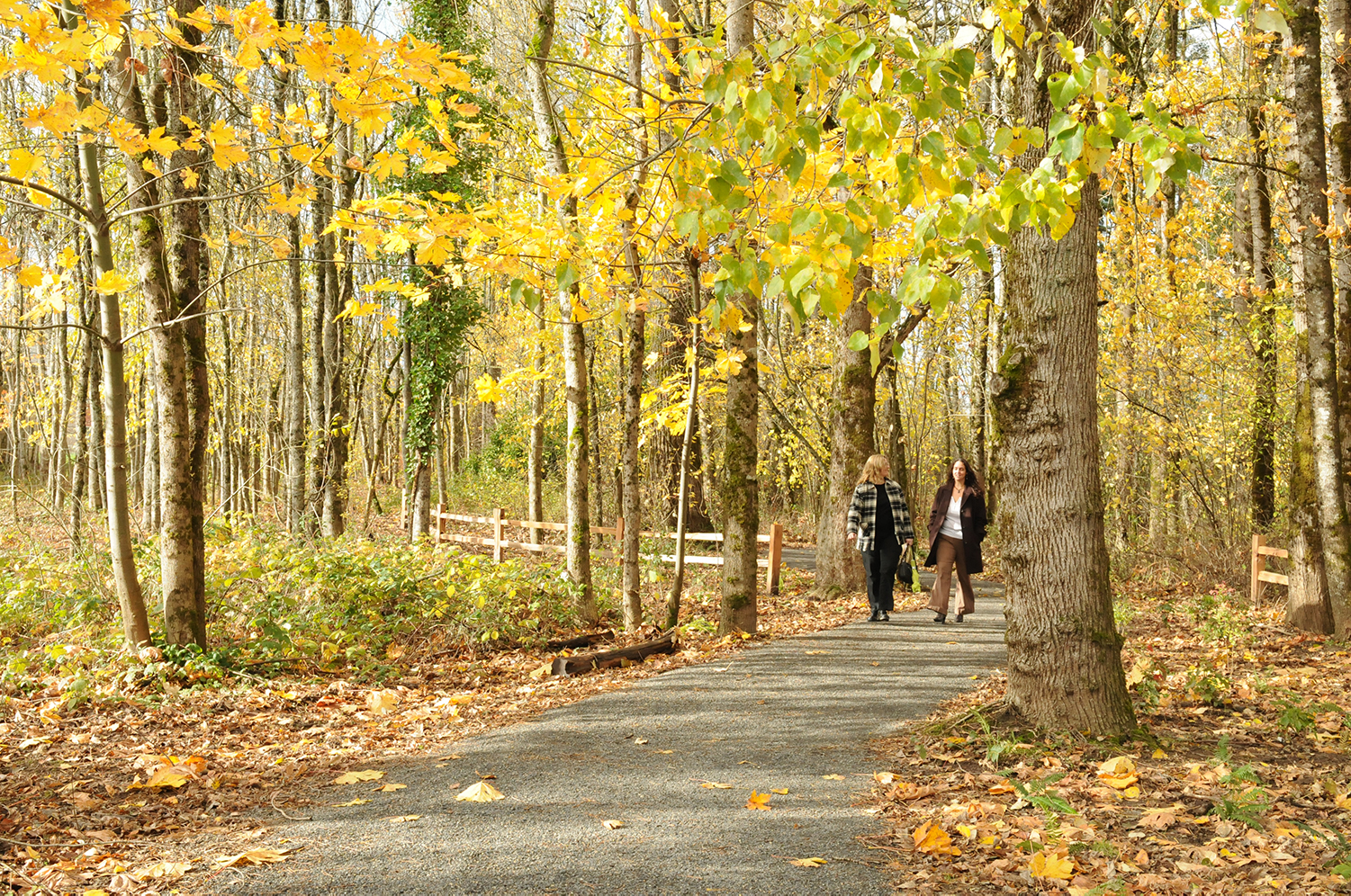
North Clackamas Parks and Recreation District and the City of Milwaukie partnered to improve in-stream and riparian areas and a new trail access at Spring Park in Milwaukie, Oregon. As the project Landscape Architect, GreenWorks analyzed the topography and sensitive areas to find the ideal location for a soft surface trail, boardwalk, and overlook that would improve access and provide excellent user experience within the restored riparian landscape.

Spring_View_01.jpg
Spring_Park_Interpretive_reduced.jpg
Spring_Park_Boardwalk_reduced.jpg
Spring_Park_Overlook_reduced.jpg

Brian Booth State Park Master Plan

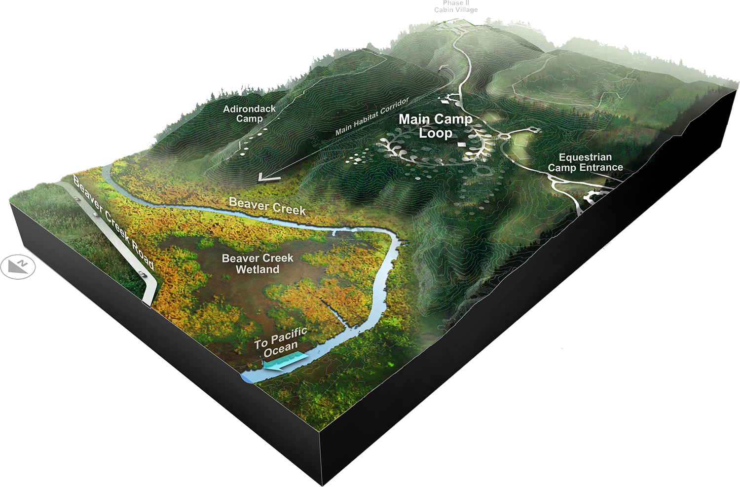
GreenWorks assisted Oregon Parks and Recreation Department (OPRD) in the development of a master plan for a large property of approximately 1283 acres of wetlands, meadows, orchard and forest just south of Newport, Oregon. GreenWorks sought to enhance the site’s valuable ecological characteristics while offering diverse recreational activities such as beach access, paddling, bird watching, and walks in the marshland and hiking in upland meadows. The master plan includes hiking, biking and equestrian trail systems, water trail access and boat ramps, a boardwalk, campgrounds, cabin areas, interpretive areas and administration areas

Brian_Booth_State_Park.jpg
12036_Preferred_Alt_reduced.jpg

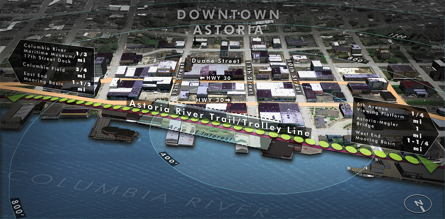
Astoria Visioning, Planning, and Wayfinding

As part of a comprehensive visioning project, GreenWorks helped to envision the future of the Astoria riverfront. The design team assisted in planning for open space and pedestrian connections that reinforce the values of the community and preserve the special character of this historic city. GreenWorks also helped facilitate visioning workshops and provided the community with imagery, plans, and strategies to guide future development. The National Oceanic and Atmospheric Administration (NOAA) honored this project with its Walter B. Jones Memorial and NOAA Excellence Awards. GreenWorks went on to develop concepts for the Astoria Riverwalk with the goal of developing a multi-modal approach that accommodates a historic trolley line, business access for deliveries, bicycle traffic, as well as a pedestrian trail along the waterfront complete with wayfinding elements. The design character for the Riverwalk elements reflects industrial waterfront themes. Sketches were prepared to show unifying themes incorporated into varied settings along the waterfront. GreenWorks also developed the wayfinding plan for downtown Astoria. The scope includes preparing a concept plan detailing locations of proposed improvements and illustrations of signage components. Working closely with the City and Downtown Association representatives, GreenWorks prepared a set of signage typologies to provide the community with a cohesive downtown wayfinding plan.

astoriawayfinding_website_061918_01.jpg
astoriawayfinding_website_061918_02.jpg
AstoriaRiverwalk_2_11th_Ave_West_2.jpg

The Confluence Project - Cape Disappointment

Cape Disappointment (formerly Ft. Canby State Park) has a vibrant history, including native peoples, explorers, US military and most recently state parks. The 1800 acre Washington State Park at the mouth of the Columbia River contains over two-hundred campsites, a boat ramp, day use areas, interpretive center and many historic coastal fortification structures. The environment is very dynamic, with coastal erosion threatening approximately ninety of the existing campsites. GreenWorks led a multi-disciplinary team in developing a 20 year Master Plan for the park, identifying new visitor service centers, administrative headquarters, maintenance facilities, multi-use trail network, interpretive facilities and restoration areas. In addition, GreenWorks oversaw the preparation of a Draft and Final Environmental Impact Statement for the project.
IMG_0030.JPG
img_4757-757x1024.jpg
DSC_0105.JPG
IMG_3387.JPG
IMG_3338.JPG
CapeD_illustrative.jpg

Deer Flat National Wildlife Refuge Master Plan

2015_06_07_Upper_and_Lower_Graphics_Options_Page_1.jpg

Located in Nampa, Idaho the Deer Flat Wildlife Refuge (DFWR) which surrounds Lake Lowell offers a unique opportunity to engage a growing urban and diverse population in connecting people to nature, while simultaneously building support for wildlife conservation. As the leading design consultant, GreenWorks is assisting the United States Fish and Wildlife Service (USFWS) in envisioning goals to protect and enhance habitat throughout the DFWR, while also supporting a variety of public recreational activities.

In accordance with the DFWR Comprehensive Conservation Plan, GreenWorks is providing planning studies for the redevelopment of the Lower Dam Recreation Area and renovation of the Upper Dam East boat launch. Through detailed mapping and site analysis, stakeholder interviews and workshops, and public involvement events, GreenWorks will generate planning and construction documents that support wildlife growth and public use of Deer Flat Wildlife Refuge. The overall need for the project was initiated by the need for ADA access to the refuge facilities. An integral part of the project is to provide ADA accessible parking, bathrooms, connection routes, fishing docks, boat ramp docks and interpretive trails that are ADA accessible. 

Lake Stevens North Cove Park

GreenWorks is providing master planning and design services for the North Cove Park project in Lake Stevens, Washington as a sub to Crandall Arambula. GreenWorks prepared an opportunities assessment on the existing open spaces including facilities along the shoreline of Lake Stevens, the Boat Launch, creek, and wetlands within the study area. GreenWorks also prepared a conceptual park and trail network design comprised of three park concepts for the North Cove Park and Lake Stevens Creek that build off the historic Lake Stevens and potential waterfront tourism destination. These conceptual plans consider integrating existing recreation uses such as rowing and boating; address both active and passive uses within the park and propose spaces for large community gatherings such as concerts, festivals, or farmers markets; enhance visual access to the Lake from Main Street; provide for additional amenities that complement the Lake Stevens waterfront and existing North Cove park, including urban plaza, greenways and other civic gathering spaces that support the area retail, housing and employment; and improve wetland and natural areas through wildlife or native planting water quality corridors to strengthen existing Lake Stevens, Catherine Creek, and other natural areas.

Plan_Perspective_Boards_061317-1.jpg
Plan_Perspective_Boards_061317-2.jpg

Independence Parks System Plan

Waterfront_Master_Plan_Independence.jpg

Over the last decade, GreenWorks has built a strong relationship with the City of Independence, providing services on a number of projects related to open space along the riverfront.
GreenWorks provided design coordination for the City of Independence’s Downtown Revitalization project. GreenWorks went on to provide conceptual design, construction documents, and construction observation for the downtown Amphitheater, Veteran’s Memorial, and Fountain at Riverview Park along the Willamette River.

GreenWorks provided cost estimates, stakeholder presentations, and constructability reviews. Project goals included the use of local or recycled materials where possible, preservation of existing vegetation, reduced water consumption, the use native plants, control of erosion, and reduced stormwater runoff. GreenWorks met with local citizens and veterans and developed a design that relocated the Vietnam Veteran’s Memorial to increase its visual presence in downtown. The new plaza and amphitheater facility has been embraced by the community and has become a major public venue for events drawing visitors from all across the Willamette Valley.


GreenWorks was then contracted with the City of Independence to update the Parks and Open Space System Plan. The plan assessed the changing recreational needs of the larger, more diverse population while also incorporating modern recreational trends. The plan also developed a new list of goals and tasks to ensure that the City can provide for the future recreational needs of the community.


Most recently, GreenWorks  redesigned a 30-acre baseball complex plan into the Independence Soccer Complex. The project’s initial phase of two soccer fields was completed in 2015.  The site also provides access to the city’s public boat launch and dock and the north end of the extended waterfront park property that links to downtown. 
 

Meinig Amphitheater

From casual visits to the playground during the weekday to 40,000 people in one weekend during the famous City of Sandy Mountain Festival, Meinig Park sees the entire range of uses and impacts from visitors. GreenWorks designed a new parking lot at the base of the park which includes pervious pavement, daylighting of an existing culverted creek that runs through the park, new sidewalks, a park trailhead and pedestrian gateway. GreenWorks designed a new amphitheater with a stage and expanded seating to accommodate larger performances.

MeinigAmphitheater_1.JPG

Multnomah Falls Concept Plan

The ultimate goal of this project was to create a vision for the iconic and historic Multnomah Falls site to improve safety and access issues from Interstate 84, to amend pedestrian access and visitor experience of the site, and to re-connect the Multnomah Creek with a natural confluence to the Columbia River. With multiple stakeholders, including the U.S. Forest Services, Oregon Department of Transportation (ODOT), Oregon Parks and Recreation Department (OPRD), the Columbia River Gorge Commission and the Columbia Estuary Partnership. GreenWorks led a multi-disciplinary team to master plan and develop a vision for the future of Multnomah Falls as a new gateway experience of the Gorge. The design team provided conceptual design, master planning, visual analysis, and a circulation Study. The team developed the concept around a comprehensive reconfiguration of the Interstate 84 Multnomah Falls interchange with a new full interchange design and access to Benson State Recreation Area and bridge crossing of Multnomah Creek. The Vision Plan includes a daylighted and restored Multnomah Creek with a natural alluvial fan to the Columbia River for fostering chum salmon habitat.

Multnomah_Falls_Birdseye_sm.jpg

Crown Park Master Plan

Crown Park.jpg

Crown Park is a cherished community park in the heart of a historic neighborhood of Camas, Washington. The 7-acre park is home to many mature fir trees and outdated infrastructure including a 1950’s outdoor swimming pool. The City of Camas hired Greenworks to assess the existing pool and park features and create a new Master Plan for Crown Park that will guide potential redevelopment for the next 20 years.  
Elements of the planning focused on economic studies for repairing or replacing the pool and updating park features including: replacing old paths with new accessible sidewalks, creating a universally accessible destination playground, incorporating an amphitheater for outdoor movies and concerts, placement for a new permanent restroom, multi-use sports court, a picnic shelter, places for sitting, and flexible open space. 

Option2.jpg

The Confluence Project - Sandy River Bird Blind

GreenWorks provided site design, agency coordination, permitting services and construction administration to the Confluence Project throughout the planning, design and construction of the Sandy River Bird Blind project.  The Bird Blind project is one of several environmental and historical art installations artist Maya Lin commissioned for the Confluence Project to celebrate the journey of exploration and discovery of Lewis and Clark.
At the end of a 1.2 mile trail, built primarily by volunteers, you stroll up a gently curving 150-foot ramp to the Bird Blind, constructed of sustainably harvested, durable black locust wood. From this quiet spot, you can view birds and wildlife that inhabit the area today as you learn about the flora and fauna-some of which are now extinct, endangered or threatened species that existed on this site 200 years ago. The artwork serves as a lasting reminder of the impact humans have had on the environment and as a model for a new way to envision the connection between people and the natural world.
The black locust wood used to build the bird blind is a long-lasting, sustainable hardwood that is considered an invasive species in the Northwest. Using locally harvested black locust for this project supports efforts to eradicate the tree from our native forests and reinforces the Confluence Project’s goal of promoting sustainability. The vertical wooden slats of the bird blind are inscribed with the name and current status of each of the 134 species Lewis and Clark noted on their westward journey.

IMG_0038.JPG
2808730787_12b0dbc1c7_bird blind 3.jpg

Fairview Woods Park

DSC_9279_reduced.jpg

Fairview Woods Park is a renovation of an existing open space to a neighborhood Park and an example of where we successfully used a sustainability filter to improve park conditions and facilities. Some trails and interpretation existed at the park but graffiti, inappropriate park use and gunfire were common in the park and neighbors were concerned about safety. GreenWorks and SWCA environmental developed a conceptual plan and construction documents to address park safety and upgrade facilities to meet neighborhood recreation needs and provide access to wetland and riparian areas. We also addressed creek and wetland protection and sustainability on site by including native plant community restoration, vegetation management to provide visual corridors, minimal tree removal, use of downed woody debris for interpretive and plaza features, wetland trail improvements, trail decommissioning, minimized parking including ADA space, and upgraded trails to meet ADA standards.

North Bethany Plan

GreenWorks is responsible for parks and open space planning, trail planning, urban design and sustainable stormwater strategies for this 800 acre new community. We are evaluating existing standards for the Tualatin Hills Park and Recreation District and will make recommendations for modifications to park system classifications and levels of service (LOS). GreenWorks will develop design approaches for a green infrastructure system that will also serve as community amenities. We are working with an interdisciplinary planning team to create a unique identity for this new community, linking natural resources, recreational opportunities and people. This integration of civic placemaking and sustainable design is a key distinctive of the future North Bethany Community.

Mirror Pond Visioning Project

GreenWorks consulted with Bend Parks and Recreation District on alternatives to provide four different solutions for the community to consider for the iconic Mirror Pond on the Deschutes River in Bend, Oregon. Each option, ranging from taking out a dam to dredging or something in between, will illustrate the visual impact, cost estimates, regulatory requirements, challenges and opportunities.

MirrorPondGIFreduced.gif

Cape Horn Trail

Cape Horn Trail is an eight-mile trail in Skamania County located twenty-six miles east of Vancouver, WA. GreenWorks is providing services for the US Forest Service for improvements to an existing trail, which has two at grade crossings where hikers and horseback riders traverse the heavily traveled State Route 14. To improve safety for trail users, the Forest Service and WSDOT are constructing pedestrian underpass tunnels at these two crossings. GreenWorks developed schematic designs for the tunnel entrances and provided construction design drawings for the tunnel fascias, which include stonewall construction, custom metal guardrail fencing design and planting design around the entrances. The design of the tunnel fascias incorporate locally quarried Columbia River Basalt to form walls that echo other examples of historic basalt stone work in the Columbia Gorge.

Cape-horn-tunnel-rendering-no-text_reduced.jpg
DSC_0767-edited_reduced.jpg

Gresham - Springwater Trail Spur

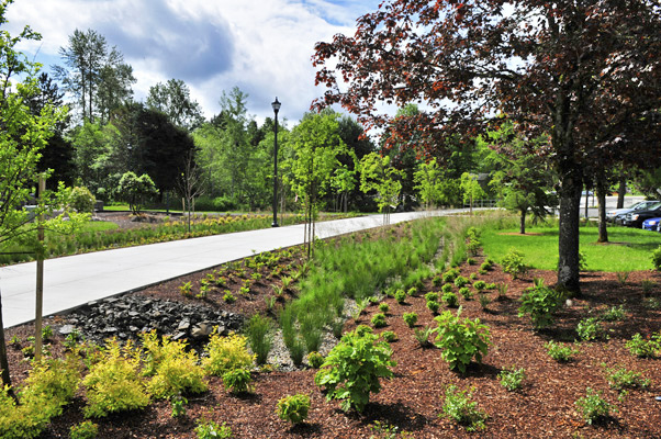
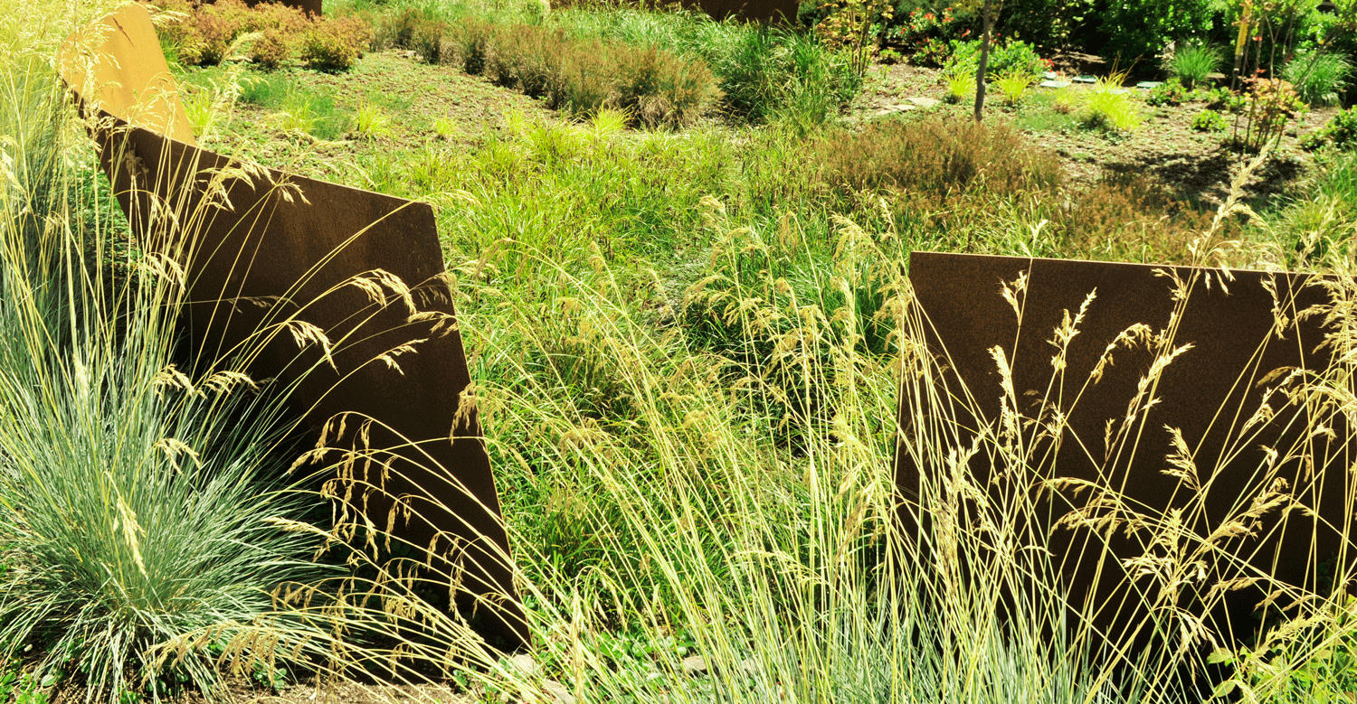
GreenWorks assisted the City of Gresham with the design of the Springwater Spur Trail project, part of the Phase One of the Main City Park Master Plan. The trail completed a significant connection between the existing Springwater Trail and Downtown Gresham through the popular 21.6-acre Main City Park. GreenWorks helped to ensure the design met the provisions of the grants and funding requirements by OPRD, ODOT and Metro. The Spur was designed as an ADA accessible, multi-use trail for pedestrians, bicycles, service and emergency vehicles. The design of the Springwater Trail Spur supports the City’s goals for sustainability by incorporating stormwater quality facilities to treat trail run-off and existing parking lot facilities that were formerly untreated. Associated features of the project include gateway design elements, landscaping, model stormwater management facilities, irrigation, lighting and trail signage. Finally, the Springwater Trail Spur created a sense of place by incorporating a new trailhead and prominent gateway feature at the south end of the trail where it abuts the Springwater Trail.

SPringwater_Spur_swale.jpg
001.jpg
Gresham_Springwater_sm.jpg