Independence Landing Waterfront Park

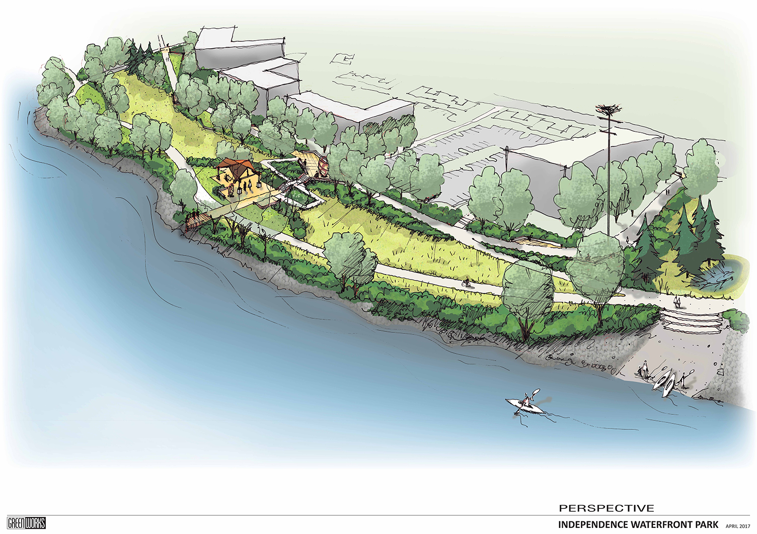
Conceived of a an extension of Riverview Park, Independence landing offers users a number of passive recreation opportunities.

Greenworks is honored to be working with the City of Independence to implement the vision set forth in the Open Space Master Plan completed in 2015. The current work on Independence Landing improves a key piece of public waterfront located immediately south of Riverview Park, the flagship of the Independence park system. Designed in tandem with the with the large waterfront re-development on the old Valley Concrete Site, Independence Landing  is one piece in a larger orchestrated effort to revitalize downtown Independence and support commercial growth.

Man-Walks_Park_Willamette_Riverfront_Path.JPG
Independence_Landing_South-View_Oregon_Waterfront.JPG

Included in the plan are a waterfront multi-use trail with a river overlook, a shaded patio and lawn space able to accommodate flexible programming, a sizeable restoration planting area braided by soft surface trails and a grove of shade trees in which the user can find informal, private seating areas. This implementation of the Open Space Master Plan sets the stage for the continued expansion of improved public waterfront southward along the Willamette River and strengthens the downtown, pedestrian connections to the waterfront.

The success of this project has been a measure of how well the project team has worked together. Shawn Irvine and David Clyne with the City of Independence and Steve Ward with Westech Engineering have been instrumental in guiding the design process, representing the diverse community of Independence and streamlining the construction of this exciting new park space.

Conceptual Visualization

Independence landing riverfront park plan graphic birdseye
Independence Waterfront Park Perspective Plan Drawing

MODA Center Exterior Project

GreenWorks provided services for the Portland Trail Blazers’ Moda Center Exterior project. The project will beautify the Center’s landscaping with native and drought-resistant plants, provide waterproofing, and replenish the grounds with healthier soils and stormwater facilities in order to reduce the site’s landscaping water use by 20-30% among other progressive initiatives. This work represents the first phase of sustainable improvements around the arena and will further the Trail Blazers’ efforts for sustainability in keeping with their ideals.

MODA_0513_small6.jpg
MODA_05186_small.jpg
MODA_05169_small.jpg

Blue Heron Mill Site Visioning

GreenWorks conducted a preliminary investigation on the Blue Heron Paper Mill site, which included research on the site’s history, river access investigations, preliminary concepts, and magnitude of cost estimate. The purpose of this work was to gain a better understanding of the potential to provide public river access, as well as for other recreational, interpretive, open space amenities and economic redevelopment features.  Celebration of the Willamette Falls and its cultural significance over the decades is also an integral component of the concept.  GreenWorks built off this initial effort to develop a vision for the site that is inspired by the 3 main eras evident on the site—the Natural Era, Cultural Era, and Industrial Era—all interweaving to become an expression of a new era of sustainability for Oregon City. New initiatives will target public open space, economic redevelopment, interpretive facilities, Falls overlooks, and riverbank restoration.

Stillwater_2_small.jpg
Mill_Run_small.jpg
River-walk_a_small.jpg
The_Falls_a_small.jpg

North Bethany Plan

GreenWorks is responsible for parks and open space planning, trail planning, urban design and sustainable stormwater strategies for this 800 acre new community. We are evaluating existing standards for the Tualatin Hills Park and Recreation District and will make recommendations for modifications to park system classifications and levels of service (LOS). GreenWorks will develop design approaches for a green infrastructure system that will also serve as community amenities. We are working with an interdisciplinary planning team to create a unique identity for this new community, linking natural resources, recreational opportunities and people. This integration of civic placemaking and sustainable design is a key distinctive of the future North Bethany Community.

East Metro Connections Plan

GreenWorks worked on team to assist Metro in the East Metro Connection Plan as a part of a regional planning effort. The East Metro Connections Plan is the first mobility corridor refinement plan to come out of the 2035 Regional Transportation Plan. The Plan has implemented a new approach to allocating limited transportation dollars to ensure regional transportation investments, support local land use, community and economic development, and the environment. The plan has been an effort to understand present and future transportation challenges and prioritize solutions that reflect community values and the future plans and aspirations of each city.

east metro connections.jpg

Willamette Riverbank Design Notebook

Hired by the City of Portland, GreenWorks led a team of biology, engineering, and erosion consultants to investigate existing bank conditions along the Willamette River in downtown Portland. The banks were inventoried by category and then color maps were created using ArcView GIS. A “Design Notebook” containing innovative design options for the Willamette riverbank was developed for the use of both public and private developers. The options were designed to create new models for an urban riverfront while protecting threatened fish species. Incorporated into the analysis of existing conditions is a description of the defining characteristics of the Willamette River Downtown area. The notebook consists of 4 major chapters: Inventory and Background, Operating Instructions, The Design Worksheet, and Design Solutions. The Design Notebook process was carefully coordinated with the National Marine Fisheries Service, US Army Corps of Engineers, Oregon Division of State Lands and various bureaus within the City of Portland. This project received a National ASLA Honor Award in 2002 and an Oregon Chapter ASLA Merit Award in 2000.

willamette riverbank design notebook.jpg

Metro Habitat Friendly Development Practices

ROW_WCSM.jpg

METRO’s Nature in the Neighborhood program utilizes education, restoration, monitoring and habitat-friendly development practices to ensure a healthy urban ecosystem. GreenWorks was contracted by METRO to conceptualize and develop watercolor illustrations depicting habitat -friendly design solutions for development adjacent to or near urban fish and wildlife habitat. Solutions depict various lands uses (single and multi-family residential; mixed-use; parking areas; and street ROW) and included greenroofs, raingardens, green streets, on-site / neighborhood / regional stormwater detention, treatment and  infiltration features, pervious pavement, reduced pavement surfaces, reduced lawn areas, and downspout disconnects.

Res_GreenRoof_wcSM.jpg
parking_01_wcSM.jpg

Lloyd Crossing Sustainable Urban Design

GreenWorks was part of an inter-disciplinary team developing a long range sustainable redevelopment plan for a mixed-use, 35 block (54 acre) area in Northeast Portland. GreenWorks’ primary responsibility was developing an open space network strategy, sustainable streetscape design concepts, rainwater harvesting on a large scale, habitat creation, and dense urban forestry approaches for the area. We also looked at creating a connection between the Lloyd District and the Willamette River through Sullivans Gulch as it existed historically. In addition to developing guidelines for the entire project area, GreenWorks developed a sustainable site plan for the “Catalyst Project.” This is a financially feasible, two-block initial phase which implements the overall district plan on a smaller scale. The “Catalyst Project” also includes the schematic design of a new public park adjacent to the development. This project received an ASLA Honor Award in the Analysis and Planning Category, 2005; AIA Committee on the Environment, Top Ten Award, 2005; and Commendation Award, Seattle AIA Honor Awards, Washington Architecture Program, 2004.

park graphic.JPG

Cape Kiwanda Master Plan

With a multi-disciplinary team that includes GreenWorks, the project provides a sustainable blueprint to improve, locate, and develop tourism facilities and infrastructure within the Cape Kiwanda Focus Area. The goals were to create a framework for tourism facilities and infrastructure to protect the beauty and natural resource values; minimize and mitigate the adverse effects of visitors; improve the visitor experience; and attract and accommodate new visitors to the region. The team collaborated with over a dozen county, state and federal agencies, including Tillamook County Parks Department and Oregon Parks and Recreation Department, and hosted public information sessions with residents, businesses and community organizations to craft recommendations for improvements to existing infrastructure. Master plan work was completed in 2016.

2016_09_07_Study_Area.jpg

Tigard River Terrace & Design Guidelines

GreenWorks assisted the City of Tigard to develop a vision for the new main street in the River Terrace community. The new center spine of the community, which is parallel to and east of Roy Rogers Road, is envisioned as a boulevard that seamlessly integrates the River Terrace Trail into its design, provides safe and comfortable multi-modal travel options, and includes high-quality pedestrian-scale design treatments that define it as the neighborhood’s signature street. In order to successfully balance mobility with safety and comfort, it is important to control speeds along this street through a variety of design approaches that facilitate through travel but discourage cut-through traffic.

Residential parking and access needs were carefully considered during the design process, including, at a minimum, an evaluation of how any proposed parking and access would impact trail users, vehicular travel speeds and volumes, and subdivision design (e.g. block length and orientation of dwelling units). The overall design of the street will serve to enhance the neighborhood and the adjacent residences without being a barrier to those who will live on either side of it in the future.

River_Terrace.jpg

St. Helens US 30 Corridor Plan

This large-scale planning project involves planning for both a state highway and main street urban streetscape. The goal of the Highway 30 project is to provide safe, convenient access to local businesses along the highway, while balancing that with state goals for traffic mobility. GreenWorks is providing design and planning overview for this project.

US 30 StHelens_Page_13.jpg

Southwest Corridor Light Rail Transit (LRT)

GreenWorks assisted Metro and its regional partners in developing a comprehensive land use and transportation planning study to identify and prioritize public investments in the corridor between downtown Portland and Sherwood. The Southwest Corridor Plan builds on 25 years of the region’s experience in light rail and high capacity transit planning and has shown that major public investments in transit bring the highest value and return on investment when done in coordination with local visions for livable communities. 


Parks and natural resources are a key component for livable communities.  GreenWorks facilitated stakeholders interviews with the project partners, existing conditions analysis and created a comprehensive inventory of parks, trails, natural resource and green infrastructure projects across the region. GreenWorks assisted in screening, evaluating, and integrating this regional comprehensive list of projects into the transit alternatives for the SW Corridor ultimately for selection of the preferred transit alternative. The plan integrates natural areas, habitat corridors and trail connections to provide a more holistic plan that elevates the value of the area’s natural resources.

SW_Corridor_Map.jpg