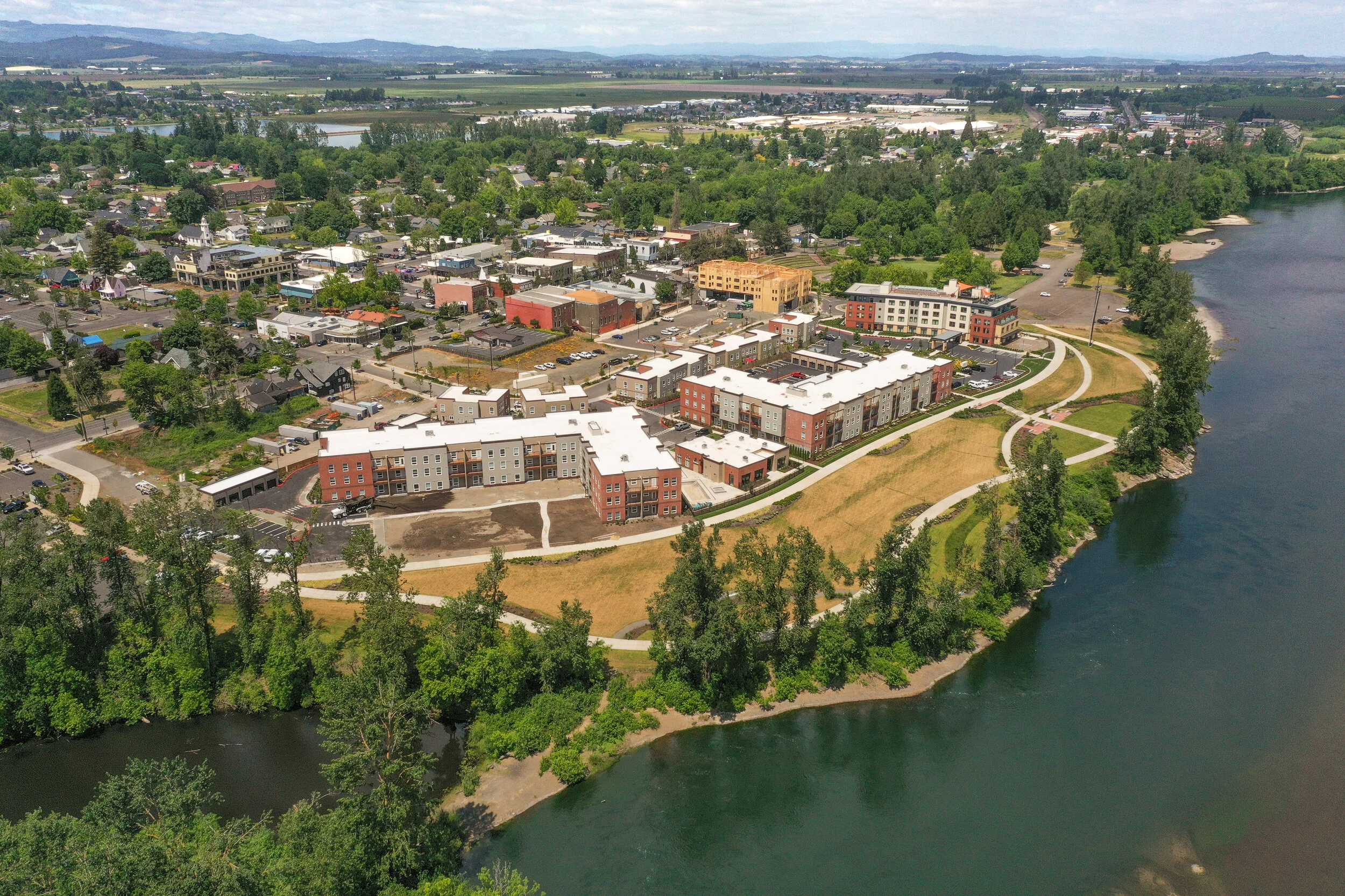
Independence Landing Waterfront Park

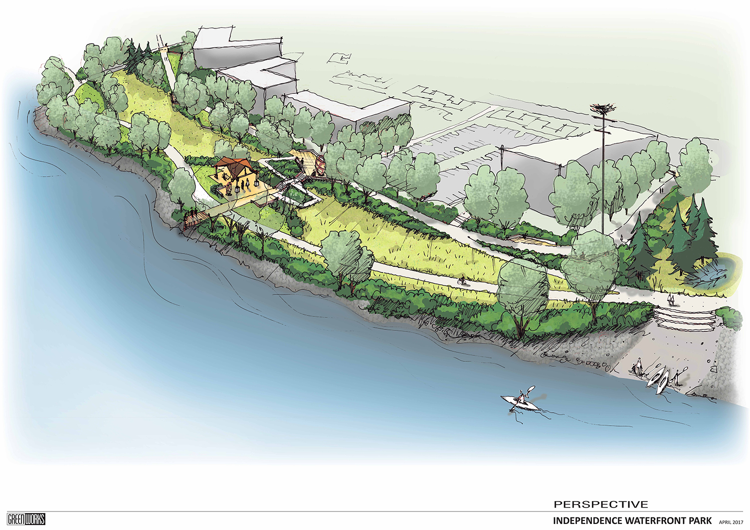
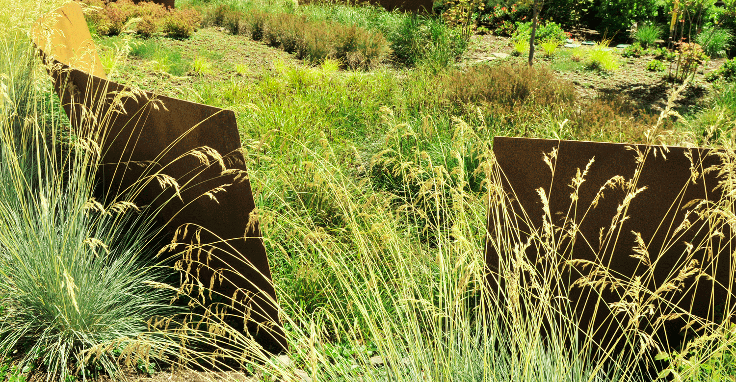
Conceived of a an extension of Riverview Park, Independence landing offers users a number of passive recreation opportunities.

Greenworks is honored to be working with the City of Independence to implement the vision set forth in the Open Space Master Plan completed in 2015. The current work on Independence Landing improves a key piece of public waterfront located immediately south of Riverview Park, the flagship of the Independence park system. Designed in tandem with the with the large waterfront re-development on the old Valley Concrete Site, Independence Landing  is one piece in a larger orchestrated effort to revitalize downtown Independence and support commercial growth.

Man-Walks_Park_Willamette_Riverfront_Path.JPG
Independence_Landing_South-View_Oregon_Waterfront.JPG

Included in the plan are a waterfront multi-use trail with a river overlook, a shaded patio and lawn space able to accommodate flexible programming, a sizeable restoration planting area braided by soft surface trails and a grove of shade trees in which the user can find informal, private seating areas. This implementation of the Open Space Master Plan sets the stage for the continued expansion of improved public waterfront southward along the Willamette River and strengthens the downtown, pedestrian connections to the waterfront.

The success of this project has been a measure of how well the project team has worked together. Shawn Irvine and David Clyne with the City of Independence and Steve Ward with Westech Engineering have been instrumental in guiding the design process, representing the diverse community of Independence and streamlining the construction of this exciting new park space.

Conceptual Visualization

Independence landing riverfront park plan graphic birdseye
Independence Waterfront Park Perspective Plan Drawing

Spring Park

North Clackamas Parks and Recreation District and the City of Milwaukie partnered to improve in-stream and riparian areas and a new trail access at Spring Park in Milwaukie, Oregon. As the project Landscape Architect, GreenWorks analyzed the topography and sensitive areas to find the ideal location for a soft surface trail, boardwalk, and overlook that would improve access and provide excellent user experience within the restored riparian landscape.

Spring_View_01.jpg
Spring_Park_Interpretive_reduced.jpg
Spring_Park_Boardwalk_reduced.jpg
Spring_Park_Overlook_reduced.jpg

Canemah Bluff

Canemah Bluff is a 300-acre natural area owned and maintained by Metro within Oregon City. GreenWorks worked with Metro to develop public access to the sensitive oak savannah and woodland, which included improving hiking & walking trails, new boardwalk, foot-bridge, and scenic overlook.

During the Public Involvement phase, GreenWorks helped engage the community and gain support from a highly motivated neighborhood group. We prepared a design that reflected both Metro’s and the neighborhood’s goals for minimal impact to natural resources, yet provided for a safe place for users to enjoy the natural area. GreenWorks produced graphic presentation materials that helped convey the design so both the client and community could fully understand and appreciate what the end product would look like once built.

20170429Canema5_reduced.jpg
20170429Canema24.jpg
20170429Canema41_reduced.jpg
20170429Canema2_reduced.jpg

Ridgewood View Park Reservoir

GreenWorks aided Tualatin Valley Water District (TVWD) in replacing an outdated reservoir with a new one adjacent to Ridgewood View Park in Beaverton. The new water project required extensive piping and construction staging on the Tualatin Hills Parks and Recreation District (THPRD) park site. In turn, TVWD needed to upgrade the amenities in Ridgewood View. GreenWork’s proposed new park elements including open lawn, paths, parking, picnic shelters, access to natural areas, playgrounds, and a bocce ball and tennis court on top of the reservoir. Innovative elements for the project included terraced rain gardens that treat and convey stormwater from the roof of the reservoir. The park’s new rain gardens help screen the 15’ wall of the reservoir in the park and provide an educational resource for TVWD, THPRD, and the residents of the neighborhood.
 

ridgewoodview_website_062118_01.jpg
Stratoscape - Ridgewood_0499.JPG
ridgewoodview_website_062118_02.jpg
ridgewoodview_website_062118_03.jpg
ridgewoodview_website_062118_04.jpg

Gresham Center for the Arts Plaza

 GreenWorks designed the new Center for the Arts Plaza in downtown Gresham for the city and its non-profit partners. The plaza is the new “living room” for Gresham and features a dramatic integration of the arts using light, water and sound. Key features include “art pillars” dedicated to literature, music, performance and fine art. Additionally, an interactive public fountain, large gathering space for concerts and dynamic lighting effects enhance nighttime activity. The plaza spills out into a “festival street” along Third Street and is host to many community events such as farmer’s markets, civic ceremonies and patrons of the Center for the Arts.

Gresham_Center_Fot_The_Arts_reduced.jpg
dscf9098e.jpg
Gresham_Arts_GW_0269.jpg

Fernhill Wetland Master Planning and Design

Fernhill Wetlands is part of a 748 acre parcel near Forest Grove, OR, owned by Clean Water Services and managed in partnership with Forest Grove.  The site, located within the Tualatin River Watershed, consists of agricultural fields, wastewater treatment and other public utility facilities, and several pristine wetlands which are open to the public and draw birders from far and wide who come to observe the many rare migratory bird species that stop at the wetlands during their journey.
With future plans to integrate the wetlands into the wastewater treatment process as part of a natural and sustainable cleansing and cooling approach that preserves the site’s ecological and recreational significance, Clean Water Services commissioned GreenWorks as consultants who bring extensive experience in constructed wetland and green infrastructure design.  In collaboration with CWS, GreenWorks developed a master plan vision for the site which included an overall site layout consisting of treatment wetlands, roads, trails, overlooks and other public spaces; a graphic representation of the water circulation path from wastewater treatment facility all the way to the Tualatin River; accompanied by a collection of artistic photorealistic renderings from various vantage points, which will collectively be used to clearly convey design intent throughout future project phases.

The Unified Sewerage Agency contracted with GreenWorks as part of a team of engineers, biologists, and hydrologists, to develop wetland development concepts for a large-scale wetland mitigation bank, along Gales Creek in Forest Grove. The concept plan recommendations included the establishment of ash forest wetland, emergent marsh and scrub-shrub wetland, wet meadows, and oak woodland upland buffers.

fernhill (1).jpg
fernhill (2).jpg
fernhill (3).jpg
Fernhill_Wetland.jpg

Zidell Green Infrastructure

Zidell_ASLA_Award_Submittal_Page_05.jpg

The 33-acre Zidell Yards site offers the first holistic, comprehensive opportunity in Portland, Oregon to identify solutions for applying green infrastructure to manage stormwater on one of the largest brownfield remediation and redevelopment sites in Portland.  The goal of this effort was to develop a range of comprehensive green infrastructure scenarios consistent with the constraints of a recently remediated brownfield that can be implemented within the framework of a 15- to 20-year development master plan.

Zidell_Board_2-2.jpg

Expo Center Stormwater Green Wall

Two Story metal structure with hexagon shapes and basins filled with verdant plants

The Portland Expo Center Stormwater Green Wall is the first of its kind in the United States. It integrates sustainability, art, and science for managing stormwater runoff.

Mature sedges and star jasmine fill a metal structure on a sunny day

Designed by a team led by GreenWorks, PC, it’s an innovative and unique project representing the next step in creative stormwater management solutions. By taking roof-runoff and routing it through a series of vegetated planters mounted to a vertical wall structure, the Portland Expo Center Stormwater Green Wall, designed with many partners including Oregon Metro, isn’t a traditional bioswale or garden. Instead, it effectively uses the available vertical square footage of the existing building to provide stormwater filtration for the 9,400 square foot roof.

“Standing 30-feet tall and 60-feet long, the free-standing, artistic structure is made of steel and aluminum and is adorned with soil and vegetation native to Oregon, particularly the Columbia River Gorge.”

Because of the stormwater wall’s prominent location, it was important that the design fit within the context of the existing site and complement the existing postmodern style of architecture. This was accomplished by giving particular attention to forms and materials. The form of the stormwater channels relate to forms evident on the existing building and the hexagons provide a decorative element that ties in subtly to the EXPO Center’s logo and brand. This project was constructed in 2014.

“There’s an educational component going on here… We want to explain how this structure is more than architecture. It’s connected to good, sustainable practices and mitigates the Expo’s footprint.” - Lydia Neill, Oregon Metro

A female mallard duck was recently photographed enjoying the Wall’s lush vegetation. Since opening in 2014, the Stormwater Green Wall has flourished. After a few winters that have broken rainfall records in the Portland Metro area, the ferns, star jasmine, sedge, and other plants are thriving. We are delighted to learn that besides processing stormwater, it provides urban wildlife habitat too!

architectural Sketch depicting metal structure with explanation of water flow
Computer generated diagram of water flow through stormwater wall during rainstorm
Stormwater wall under construction using cherry picker with men in hardhats
Completed stormwater wall on a partially sunny day with inverted metal cone

Kenton Denver Avenue

Portland’s first green main street, the Denver Avenue Green Street extends along the four-block historic Kenton business district in north Portland. The initial phase of the streetscape design developed an overall concept for the street section, including the widening of sidewalks, addition of bike lanes, and the restructuring of existing parking, drive lanes and medians. The design developed through input from a Citizen Advisory Committee, a Technical Advisory Committee, and with extensive public involvement at open house meetings. GreenWorks, as part of a multi-disciplinary team, prepared an overall street layout for the corridor that defined paving patterns, materials, street trees, site furniture, ornamental light fixtures, and the design of gateways at either end of the corridor. An important component was the integration of green street stormwater solutions within the right-of-way. This project was completed on time and on budget.

Our initial design work moved successfully into a constructed streetscape project in 2010 with GreenWorks providing construction documentation led by the Portland Bureau of Transportation. As a main street and ODOT-designated freight route, we successfully integrated sustainable design with main street design to create a vibrant streetscape. Long suffering from a high storefront vacancy rate, the Kenton downtown now has experienced a boom in new businesses and its local economy.


“And now in 2020, as the coronavirus pandemic and the attendant economic crisis have walloped businesses, communities, and Main Streets across the nation, Denver Avenue is again going through a transformation. The Kenton Business Association, working closely with Portland’s Bureau of Transportation and Salazar Architect, have created #DenverAvePlaza – prioritizing parts of the roadway for outdoor commerce, dining, displays, and socially-distanced gathering. While the new plaza has gone through a couple of changes, the Business Association reports that “what has not changed is our determination to make the Plaza in whatever shape as safe and as enjoyable a space as possible.” This latest iteration of Denver Avenue clearly emphasizes the importance that public space has for us even in these hardest of times (and even if Paul Bunyan has to wear a mask).”

- SERA Architects, Summer 2020


DenverAvenue_reduced.jpg
Kenton1.jpg

BES Johnson Creek Oxbow Restoration

IMG_9919.jpg

In November of 2014 GreenWorks began a site assessment and preliminary design for the Johnson Creek Oxbow Enhancement Project. The central feature of the site is the namesake “Oxbow” meander, which is bounded on the south by a bypass channel that truncates the oxbow creating an island. The by-pass channel was constructed by the Works Progress Administration (WPA) in the 1930’s and included armoring the creek bed and banks, and creating a fish ladder in the oxbow to maintain fish passage. The goal of the WPA work was to convey flood flows efficiently downstream. It resulted in a confined channel, which is hydrologically disconnected from adjacent floodplains and wetlands, and exacerbates flooding. GreenWorks was charged with providing design strategies for improving floodplain hydrology, riparian and in-stream habitat, and local flood impacts.


To support these goals, GreenWorks held a one day charrette, which included members from BES, ESA-Vigil Argimis, and KPFF to discuss and recommend a variety of design strategies for improving the inherent conditions found within the Johnson Creek Oxbow. Recommendations were collected and vetted amongst the consultants and further discussed with BES to determine a set of design alternatives for specific sites within the project area. Project sites were mapped, along with support graphics and images, and cost-estimates, to BES in a comprehensive Pre-Design report, thus allowing BES to prioritize future improvement projects for the Johnson Creek Oxbow area.

BES_Oxbow_Perspective.jpg

BES Flyway Wetlands Enhancement

GreenWorks provided landscape architecture services for Portland’s Bureau of Environmental Services Flyway Wetland property located between the Columbia Slough and the Columbia River near the Portland airport. GreenWorks led a team to provide several wetland restoration concepts and a wetland delineation report. GreenWorks headed several workshops with the consultant and team to develop the preferred concepts based on goals for the project including: water quality improvement; vegetation and habitat restoration; wetland hydrology improvement; and floodplain wetland hydrology improvements. Wetland and Stream Delineation Reports and Wetland Restoration Concepts were created for internal analysis related to bureau’s goals for restoring the site and their overarching restoration goals for bureau’s environmental group.

Flyway_Wetlands_Sections_Mosaic.jpg
Flyway_Wetlands_Sections_Bayou.jpg
Flyway_Wetlands_Plan_Concepts_Mosaic.jpg
Flyway_Wetlands_Plan_Concepts_Bayou.jpg
Flyway_Wetlands_Design_Concept_Table.jpg
flyway (5).jpg
flyway (1).jpg

BES Columbia Slough Stormwater Retrofit Inventory

In January 2010, GreenWorks and BES staff conducted intensive field work locating and documenting potential locations for stormwater facilities throughout the Columbia Slough Watershed in North Portland. The Columbia Slough has been designated a high priority area by the City of Portland for improving watershed health and reducing pollutants. The project team focused on four target areas where green street facilities would maximize stormwater quality treatment and capture contaminated sediment before being discharged into the Slough. Each potential green street facility was ranked based on its potential performance, feasibility, and cost. GreenWorks assisted BES in project prioritization and provided an overall ranking using Geographic Information Systems (GIS). Over 150 potential green street facilities were identified, which would potentially result in stormwater treatment from over 35 acres of impermeable surfaces.

Columbia Slough Project Prioritization.jpg
Overall Map_Labels.jpg
Target Areas.jpg

Albany Stormwater Standards

Albany_Stormwater3.jpg

GreenWorks has worked over the past several years with City of Albany staff to develop stormwater quality standards for development to meet DEQ regulatory requirements.  The products include new and  updated sections of City Administrative Codes, Development Codes, Engineering Standards, Standard Construction Specifiations, and Standard Drawings.   The draft products are currently in the public review process, with adoption and implementation tentatively planned by the end of 2014.  Draft documents are all available for review on the City of Albany/Public Works/Engineering web page.

Streetside_Shallow_Swale.jpg
Albany_Stormwater_illustrations.jpg
Albany Stormwater.jpg

Empire Boulevard

The City of Coos Bay received federal funding to install bike lanes, landscape strips, and sidewalks to Empire Boulevard between Newmark Avenue and Wisconsin Avenue to provide alternative transportation opportunities along this heavily traveled corridor.

Improvements include widening the existing two-lane road to make room for on-street parking and bike lanes, installing curb, gutter, landscape strips with street trees, and sidewalk on both sides of the road. Stormwater / water quality facilities are constructed to manage stormwater on-site, converting Empire Boulevard into a ‘green street’. Other project elements include interpretive overlooks with site furniture, illumination, signing, striping, and numerous driveway connections.

Empire Blvd Coos Bay.jpg