

People and Climate at Center of Updates to Influential Transportation Guidelines
/
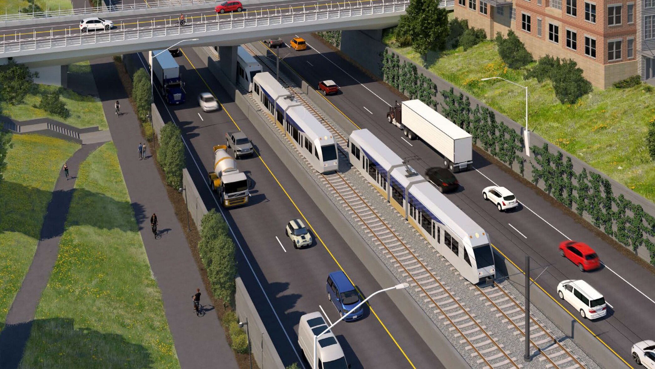
Image courtesy of Metro
On October 24th, 2019, Metro, our Portland metropolitan area regional government, released an updated version of their “Designing Livable Streets and Trails Guide.” GreenWorks was part of the team that contributed updates to it.
“Metro’s Designing Livable Streets and Trails Guide provides design guidance for our regional streets and trails. The guidelines were developed to help implement the 2040 Growth Concept and the Regional Transportation Plan.”
It’s a set of design guidelines that require transportation infrastructure to be designed to serve the people and environments they’re built in, not just the vehicles that use it. The updates refresh the well-known guide and provide some important updates, prioritizing livability, safety, and reducing our greenhouse gas emissions.
We’re particularly proud of our work because Metro will be requesting money from voters through a transportation bond this November that will use these guidelines if funded.
Metro hired Kittelson & Associates to partner with GreenWorks, sparks+sullivan, and KLiK Concepts to develop graphics, write new guidance for innovative stormwater infrastructure, and update information about integrating trails. That means our input may have a big impact on our region’s future.
“The guide acknowledges the negative impacts transportation can have on water,” said Lake McTighe, senior transportation planner at Metro. “It highlights how important green streets can be to solving this.”
It’s forward-thinking policy that has roots in some interesting history.

“A transformational event… the beginning of serious efforts to integrate land use and transportation planning.”
In 1997 Metro released a document called “Creating Livable Streets” and soon after staffers began to see and hear of consultants and agencies across the country referring to it. A simple Google search reveals hundreds of planning documents and academic articles that cite it. “The guide made the connection between land use and transportation design, which was a new approach,” McTighe said. But innovation in Oregon transportation design goes even further back than that.
“The guide made the connection between land use and transportation design, which was a new approach.”
When Senate Bill 100 passed, in 1973, it created Oregon’s modern land use planning system. It’s an innovative way we’re prevented the limitless sprawl seen in many other places. Oregon was the first in the country to do this. The momentum built by then Governor Tom McCall and the Portland community got the bill passed and then, with the help of the newly passed Environmental Protection Act, went on to stop the Mt. Hood Freeway and replace it with the beginnings of Portland’s first light rail line. The State of Oregon’s planning department calls this moment, “A transformational event that marks the end of freeway construction and the beginning of serious efforts to integrate land use and transportation planning.”
Today, the region is dealing with a whole host of new challenges, including systemic inequity, climate change, congestion, and loss of natural space. Metro was created in 1979, and since then has led the region through these new challenges, creating processes and protections so this legacy of livable communities, rooted in innovative land use, continues. One way they’ve addressed these challenges is through coordinating the growth of cities in our region today through transportation planning.
The 1997 guide was developed to improve Metro’s 2040 Growth Concept, “a big vision for how to grow, in centers and in corridors,” McTighe said, “but there was the realization we needed transportation guidance to be sure it met the concept’s needs.”
Examples of the original guide’s effectiveness can be seen all over metro region. “We’re seeing designs with more bioswales, medians, pedestrian crossings, better connectivity, better protected bikeways, and transit design that improves service and access,” McTighe said. She cited neighborhoods across Portland, Lake Oswego’s A Avenue and Downtown Oregon City as examples.
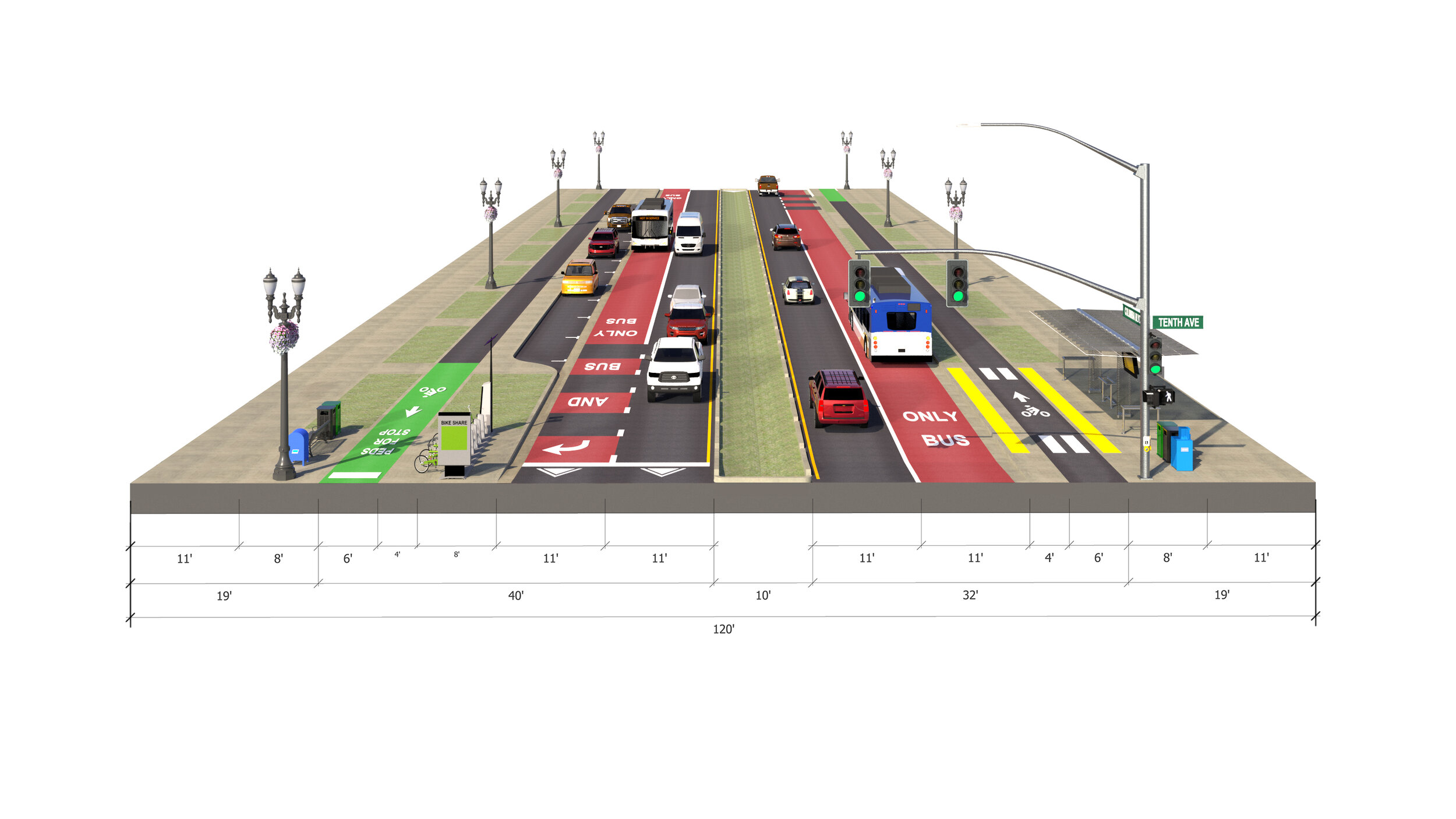
“The old guide simply called for five-foot-wide bike lanes. Since that time there has been so much progress on design for bikeways, they’re safer and more comfortable now,” McTighe said. “Or take what used to be known simply as parking space. Now it’s known as a ‘flex zone’, able to be converted to bikeways, bus only lanes, wider sidewalks, or street seats.”
In 2002, Metro released an update to the 1997 edition and added new guides, to go alongside it, called “Green Streets”, “Trees for Green Streets”, “Wildlife Crossings”, and “Green Trails”. The new edition released on October 24th is the most recent update since that time and integrates the 2002 additional guides into one really useful document.
“In 1997, the Creating Livable Streets guidebook was published, presenting what was then a radical new approach to transportation design that crossed traditional boundaries between land use and transportation planning and linked street design to community livability. ”
GreenWorks’ Wes Shoger, Mike Faha, Kelly Stoecklein, and Gill Williams all contributed to the guidelines by writing sections that explain how to integrate trails and stormwater management best practices into our region’s streets, and co-produced the illustrative graphics with design studio sparks+sullivan and KLiK Concepts.
“The document gives an accessible overview of elements planners and designers should consider when creating streetscapes and transportation corridors,” Wes Shoger, landscape architect at GreenWorks, said. He said team worked hard to strike a balance between important technical information and readability, so more agencies and people can understand and implement its recommendations.
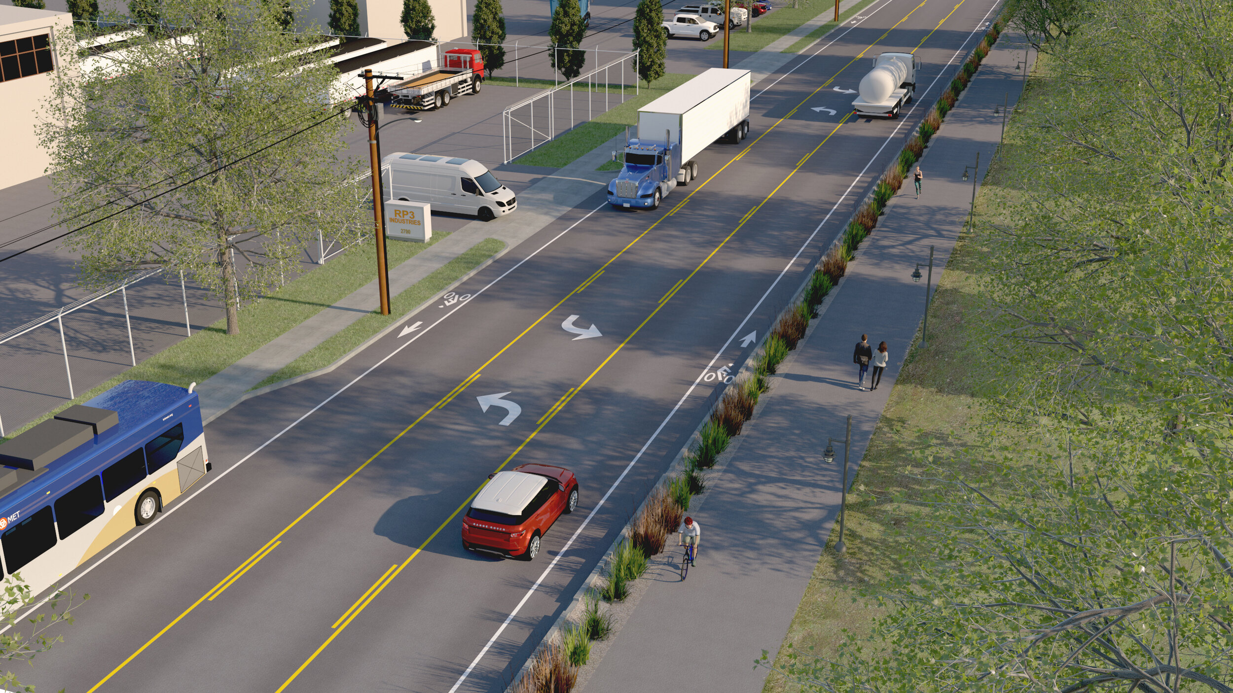
The new version also includes visualizations, streetscape renderings, illustrations showing the integration of green streets and safe streets.
“When the first guide was produced, there were only a few examples of innovative stormwater management going on in our region,” McTighe said. “Since then, a lot of projects have been done in the region, there are many local examples we can now point to. Designers can actually go see examples in action.”
Image by GreenWorks and sparks+sullivan
“We looked beyond just Downtown Portland,” Shoger explained. “We made sure we got out of the office and visited as many different kinds of street configurations in our region as we could.” Because the team did this the guide features stormwater examples in urban, rural, and suburban contexts.
“We advocated for a more localized approach to treating stormwater. Unfortunately, in much of the built environment you see highly centralized approaches that involve collecting stormwater and sending it away somewhere else to be treated. A localized approach is much better, in most circumstances, as it can reduce conveyance pipe runs and make the stormwater approaches integral elements of the streetscape,” Shoger said.
McTighe highlighted the addition of a decision-making framework in chapter six as an important feature. “It’s a more holistic, process-focused structure that begins with questions.” Changes like this are important because they depart from the more traditional “standards-based” design approach, which can be inflexible and insensitive to a project’s context, the way land is used around it. The guide calls for a route to decisions that seriously assesses impacts on climate, equity, safety, and increasing transportation access.
“It’s exciting to me because it builds on documents that have been important references for nearly 20-years,” Shoger explained. He said that they’re invaluable to smaller towns in the metro area because some might not have resources to develop their own design guides. “It’s something they can reference when creating engineering documents. It’s not prescriptive, but it’ll help a city like that plan transportation corridors with fresh ideas. It’s particularly useful at the planning stages.”
“This guide was developed over a multi-year collaboration with agencies across the region. There is diverse growth happening across our region. We want the guide to be used and to provide valuable resources to agencies across the region. This is everyone’s guide.” McTighe said.
We worked on the project with Kittleson & Associates, Inc., sparks+sullivan, KLik Concepts, Metro and Metro Project Manager Lake McTighe. Images in this post are courtesy of Metro, Kittleson & Associates, Inc., sparks+sullivan, KLiK Concepts, and GreenWorks, P.C.